


PERTH, Australia, Feb. 23, 2026 (GLOBE NEWSWIRE) — Alkane Resources Limited (ASX: ALK; TSX: ALK; OTCQX: ALKRY) (‘Alkane’ or ‘the Company’) is pleased to announce the latest exploration results and drilling for the underground expansion of existing resources at its Tomingley Gold Operations (Tomingley) in New South Wales.
Program Summary
- Exploration drilling at Tomingley has tested a seismic reflector feature beneath the Roswell Deposit and near-mine prospects such as El Paso. Underground drilling at Roswell, outside of grade control, has focused on improving confidence in the Inferred Resources.
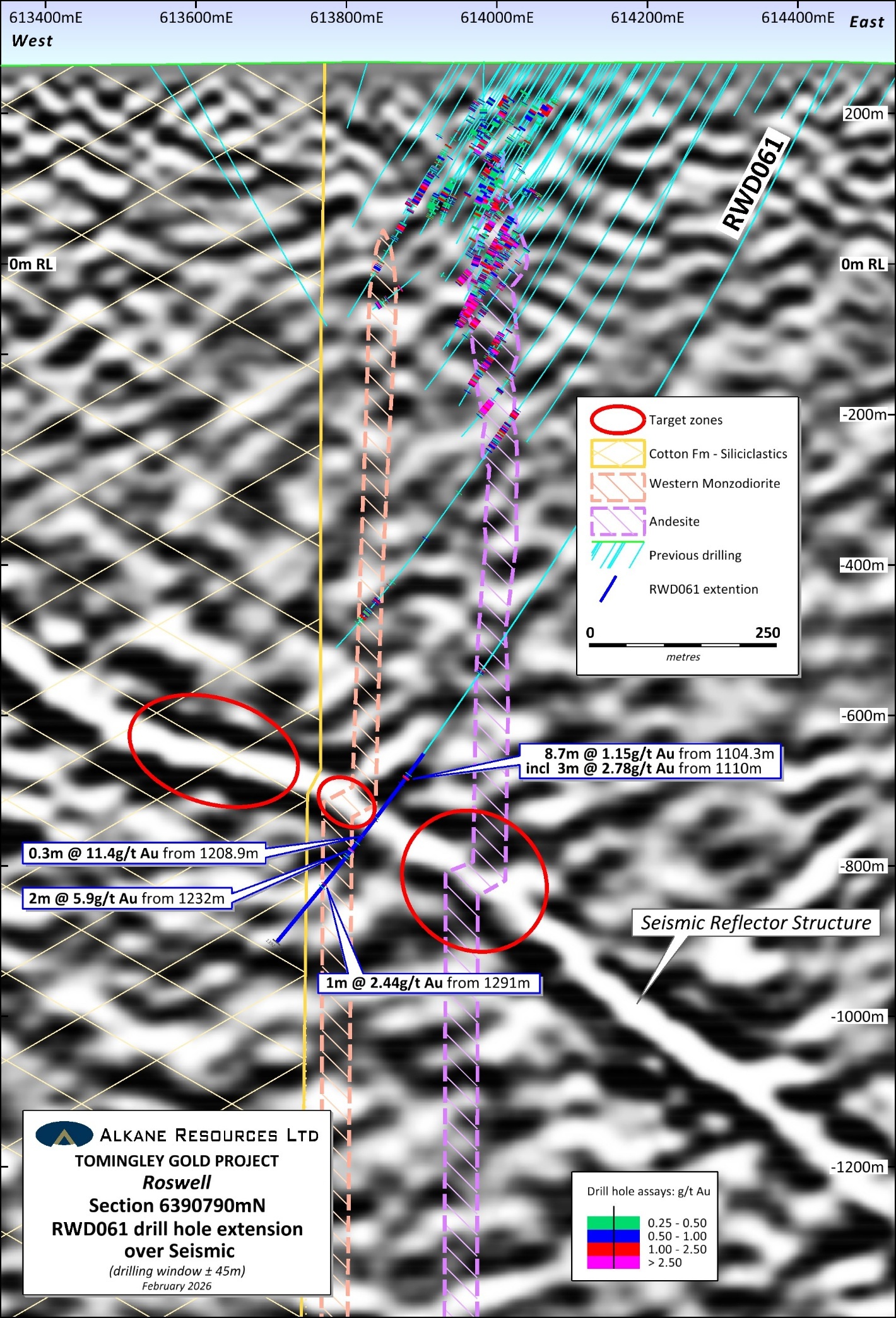
- Roswell underground resources (1.3g/t Au cut-off) are estimated at 5.5Mt grading 2.6g/t Au for an endowment of 476,000 oz Au1. A previous exploration drill hole (RWD061) was extended to 1,392m depth to intersect a seismic reflector identified ~400m below current resources. The drilling identified the east dipping reflector as gold-arsenic enriched hydrothermal breccias and veining.
- A program of underground drilling at Roswell targeting the Inferred Resources hosted by the Western Monzodiorite domain was completed. Results for this program testing the mid-portion of the domain to a nominal 15m x 20m grid spacing were received from the final 21 drill holes, totalling 4,019m. The program has confirmed multiple high-grade gold zones within the monzodiorite.
- Exploration drilling of 7 diamond core drill holes at the El Paso prospect and 1 RC drill hole at the Westray prospect. All drilling intersected quartz veining with gold-arsenic mineralisation, hosted in the prospective Mingelo Volcanic stratigraphy.
Assay Highlights
- Roswell Seismic target (RWD061):
- 8.7 m grading 1.15g/t Au including 3 m grading 2.78g/t Au;
- 0.3 m grading 11.4g/t Au;
- 2 m grading 5.90g/t Au.
- Roswell Western Monzodiorite underground drilling:
- 5.9 m grading 31.0g/t Au including 2.1 m grading 78.4g/t Au (ROSUG657D);
- 17.4 m grading 4.30g/t Au including 2.5 m grading 21.1g/t Au (ROSUG644D);
- 3.5 m grading 16.1g/t Au including 1.2 m grading 45.1g/t Au (ROSUG425D);
- 0.6 m grading 69.2g/t Au (ROSUG656D).
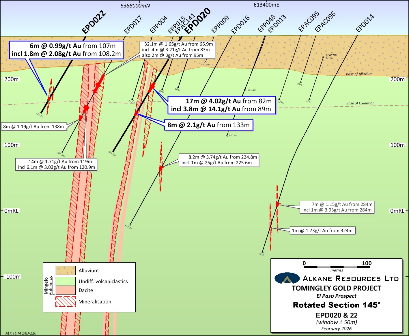
- El Paso exploration drilling:
- 17 m grading 4.02g/t Au including 0.5 m grading 77.5g/t Au (EPD020);
- 8 m grading 2.10g/t Au (EPD020).
Alkane Managing Director & CEO Nic Earner said: “Our continuing exploration at Tomingley reveals both extensions to our deposits, which remain open at depth and along strike, as well as new areas of mineralisation. This drilling demonstrates the significant resource expansion potential across the mine site, we look forward to revealing this potential, both near mine and regionally around Tomingley.”
1 Refer to ALK Announcement dated 15 October 2025 titled ‘NSW Resources and Reserves Statements FY25’.
‾‾‾‾‾‾‾‾‾‾‾‾‾‾‾‾‾‾‾‾‾‾‾‾‾‾‾‾‾‾‾‾‾‾‾‾‾‾‾‾‾‾
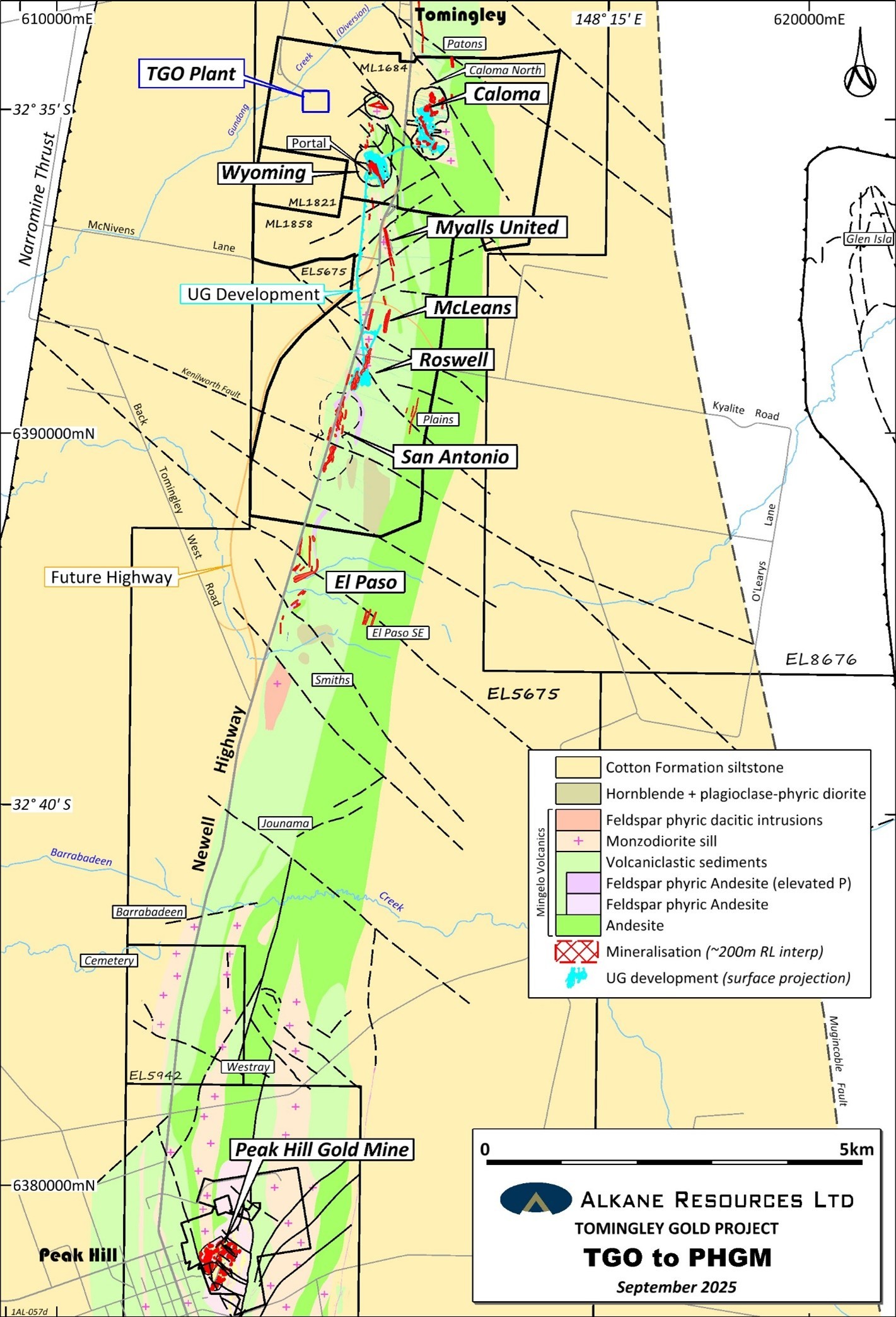
Tomingley Gold Operations (TGO)
Alkane Resources Ltd 100%
Tomingley Gold Mine is an open pit and underground mining development with a 1Mtpa processing facility in operation since 2014. The development is located near the village of Tomingley, approximately 50 kilometres southwest of Dubbo in Central West New South Wales. Tomingley Gold Operations Pty Ltd is a wholly owned subsidiary of Alkane.
Development at Tomingley has been based on the Wyoming One, Wyoming Three, Caloma, Caloma Two and Roswell gold deposits. To date, mining occurred underground at Wyoming One, Caloma, Caloma Two and Roswell deposits. Roswell stope ore production came on stream in April 2024 (ASX Announcement 22 April 2024) via an approximately 3 km decline from the Wyoming One open cut.
The Tomingley deposits are located within a tightly folded Ordovician volcano-sedimentary sequence that has been altered to a sericite-carbonate-albite-quartz-pyrite-arsenopyrite assemblage, typical of orogenic lode-style gold deposits. Mineralised fluids are interpreted to have been focused by differential strain in and around andesitic volcanics due to the rheological competency contrast between the volcanics and the bounding volcaniclastic sediments. The brittle nature of the volcanics often leads to the development of shear-hosted sheeted quartz vein and breccia deposits within and adjacent to the andesitic bodies. Separately, thin carbonaceous mudstone strata appear to have been a focus for shearing and a chemical trap for gold.
Since underground mining commenced in 2018, extensive underground drilling has been employed to define ore reserves for extraction and maintain exploration to define additional resources. The most recent Reserves and Resources were summarised in the ASX release on 15 October 2025 “NSW Resources and Reserves Statements FY25”.
Roswell
The Roswell underground resources (1.3g/t Au cut-off) are estimated at 5.5Mt grading 2.6g/t Au for 476 oz Au (see table titled TGO Mineral Resources at 30 June 2025). The previously deepest exploration drill hole (RWD061 – ASX announcement 17 November 2022) at Roswell was completed to 1,002m. This hole was recently extended by another 390m with HQ3 diamond core drilling to intersect a seismic reflector identified by the reprocessed 2D seismic survey data in 2024 (see ASX announcement 7 October 2024). This reflector, identified in three 2D seismic traverses, is dipping ~30o to the east with more than a 5km strike length, is interpreted to be a major fault or conduit for the upwelling of gold-arsenic enriched hydrothermal fluids to the Tomingley gold system.
The drill hole intersected several hydrothermal breccias, and quartz veining in a similar orientation to the seismic reflector surrounded by an intense silicification alteration halo hosted in volcaniclastic metasediments. Visible gold was observed in one of the breccias. The reflector zone was also characterised by zones of intense arsenopyrite mineralisation associated with low gold grades, such as 7 metres grading 0.16g/t Au and >0.5% As from 1,176 metres. Footwall to the seismic reflector, the hole intersected the down dip and normal offset extensions to the Western Monzodiorite (MZD) that was also mineralised. In summary, significant gold intercepts from the extension of RWD061 include:
| RWD061 | 8.7 metres grading 1.15g/t Au from 1104.3 metres; | |
| incl | 3 metres grading 2.78g/t Au from 1110 metres; | |
| and | 0.3 metres grading 11.4g/t Au from 1208.9 metres (visible Au); | |
| and | 2 metres grading 5.90g/t Au from 1232 metres (MZD); | |
| and | 1 metre grading 2.44g/t Au from 1291 metres (MZD). | |
The reflector where intersected by RWD061 is hosted by metasediments. As observed at the Tomingley deposits, higher gold grades and broader intercepts will likely occur where mineralised structures intersect a favourable rheological and chemical host lithologies such as the andesite or monzodiorite at Roswell. Further drilling is planned in the areas above and below RWD061 to test where the conduit structure intersects the Andesite and the MZD. The flexure in the reflector albeit in the metasediments of the Cotton Formation is also a favourable structural setting and is also planned to be tested.
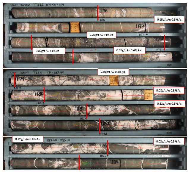
RWD061 – Subvertical meta-sediments with cross-cutting shallow east dipping sheeted quartz-arsenopyrite veins and breccias (7m interval grading 0.16g/t Au and >0.5% As from 1,176 m).


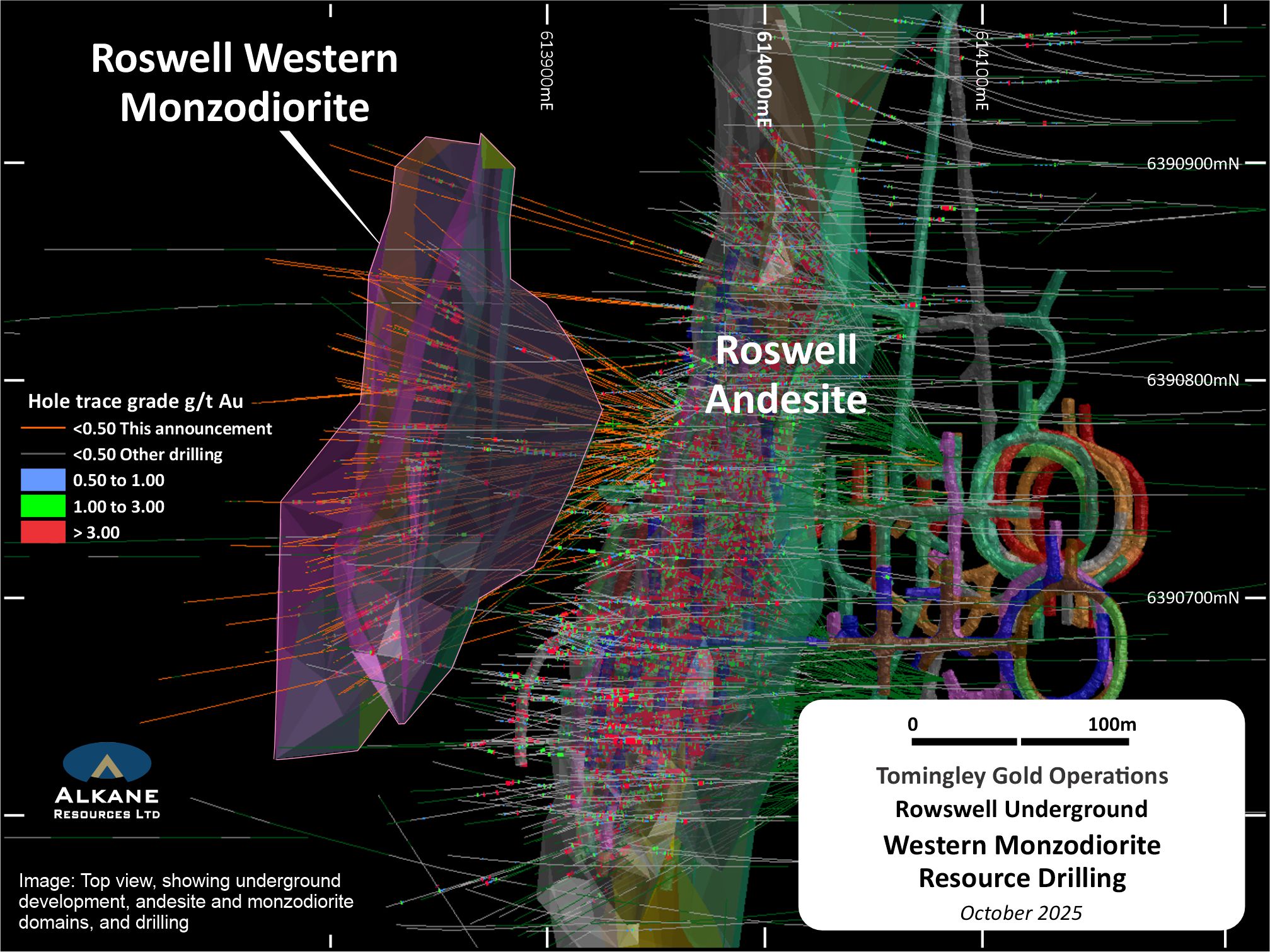
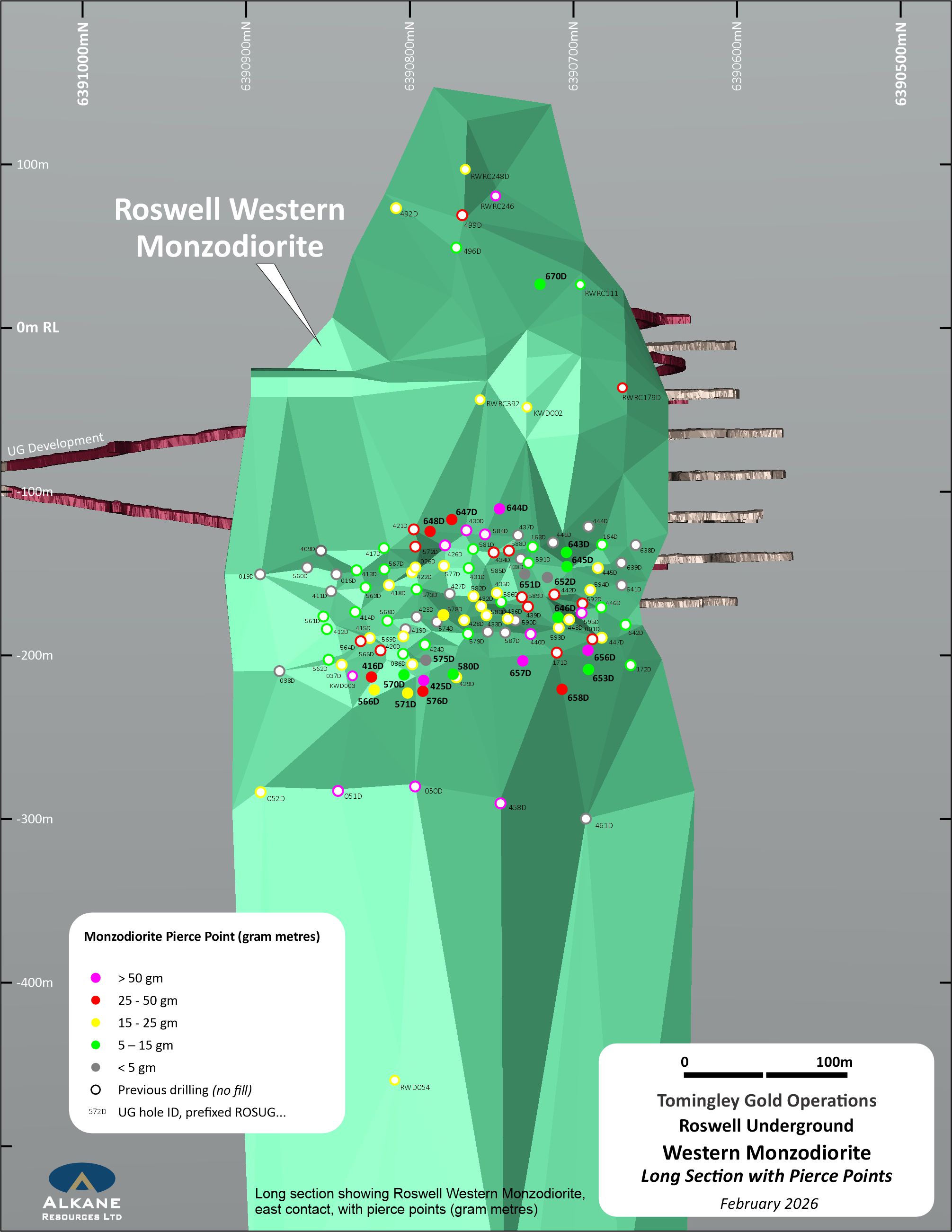
A significant portion of the Roswell underground Inferred Resources (408 kt grading 1.9 g/t Au – ASX Announcement 15 October 2025) is hosted in the Western Monzodiorite domain. A program of intensive underground diamond core drilling targeting the mid-portion of the Western Monzodiorite domain within the Inferred Resources was recently completed. The drilling will improve the confidence of the Mineral Resource Estimation (MRE) and provide a basis for conversion to Ore Reserves.
Results have been received from 21 holes totalling 4,019 metres that are targeting the mid-portion of the monzodiorite domain infilling existing drilling to a nominal 15m x 20m grid spacing for the purpose of converting to an Indicated Resource. The drilling confirmed multiple wide, high-grade gold intercepts within the 30 m thick monzodiorite, particularly along its western margin. Best intercepts include:
| ROSUG425D | 3.5 metres grading 16.1 g/t Au from 155.8 metres; |
| incl | 1.2 metres grading 45.1 g/t Au from 158.1 metres. |
| ROSUG576D | 0.6 metres grading 20.7 g/t Au from 128.3 metres; |
| and | 12.8 metres grading 1.96 g/t Au from 157 metres; |
| incl | 1 metres grading 14.0 g/t Au from 157 metres. |
| ROSUG647D | 10.1 metres grading 3.81 g/t Au from 110.6 metres. |
| ROSUG656D | 3.6 metres grading 7.31 g/t Au from 187 metres; |
| incl | 1 metres grading 24.6 g/t Au from 189.6 metres; |
| and | 1.3 metres grading 38.7 g/t Au from 195.6 metres. |
| ROSUG657D | 0.5 metres grading 13.5 g/t Au from 151.3 metres; |
| and | 3.7 metres grading 3.62 g/t Au from 168.7 metres; |
| and | 5.9 metres grading 31.0 g/t Au from 177.9 metres; |
| incl | 2.1 metres grading 78.4 g/t Au from 177.9 metres. |


El Paso and Regional Exploration
Recent regional exploration to generate new targets for discovery of gold resources outside of the Tomingley Gold Operations has included 3,341 metres of air-core drilling testing areas of covered bedrock, a high-resolution drone magnetic survey, and rock chip sampling of outcropping areas. Assay results were received from target testing exploration comprising of seven mud rotary pre-collared diamond core drill holes at the El Paso prospect and one RC drill hole at the Westray prospect.
At El Paso, a total of 1,964 metres were completed to test the extent of dacite-associated gold mineralisation such as 32.1m at 1.65g/t Au from 66.9m and 6.1m at 3.03g/t from 120.9m (EPD017 – ASX announcement 14 August 2025), according to the interpretation of a moderately SE-dipping sill. When most of the holes failed to intersect the dacite, the interpretation was reviewed with the data from the new drilling and relogging of earlier holes. The new interpretation has three distinct dacite lavas that strike NNE and dip subvertical to the WNW. One drill hole (EPD024) was also planned to test for an offset to the dacite northwest of a significant northwest striking fault. The drilling did not intersect dacite. Whilst the current drilling orientation was not optimal to test this new interpretation and any future drilling will be now collared from the west, significant gold mineralisation was still intercepted including:
| EPD020 |
17 metres grading 4.02 g/t Au from 82 metres; | ||
| incl | 3.8 metres grading 14.1 g/t Au from 89 metres; |
||
| incl | 0.5 metres grading 77.5 g/t Au from 92.3 metres; |
||
| and | 8 metres grading 2.10 g/t Au from 133 metres. |
||
| EPD021 |
9.6 metres grading 0.80 g/t Au from 60 metres; | ||
| incl | 1 metres grading 4.41 g/t Au from 64 metres. |
||
| EPD022 |
2 metres grading 1.18 g/t Au from 97 metres; | ||
| and |
6 metres grading 0.99 g/t Au from 107 metres. |
||

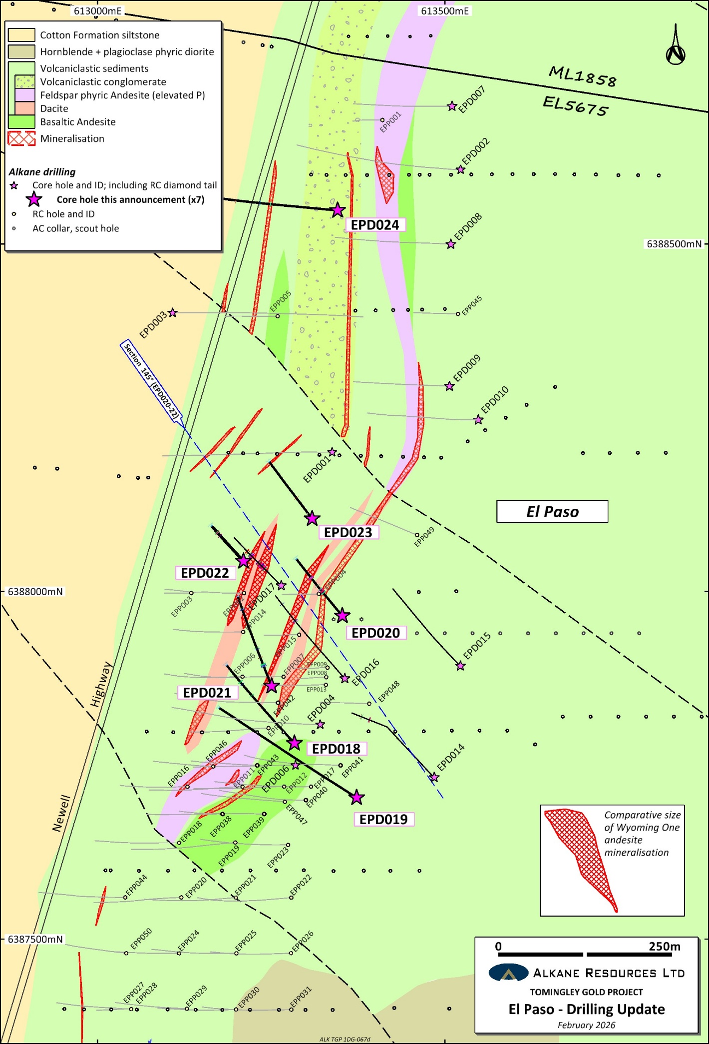
Previous air-core and soil sampling identified the Westray prospect as a multipoint Au-As target hosted in the prospective Mingelo Volcanics (ASX announcement 14 August 2025). The prospect had not been previously tested by RC or diamond drilling. One RC drill hole was recently completed to 194m to test the shallow gold mineralisation at depth in fresh rock, intersecting significant results of:
| WSRC001 | 1 m grading 2.49 g/t Au from 115 metres; |
| and | 6 m grading 0.59 g/t Au from 143 metres. |
The drill hole intersected a thick package of volcaniclastic metasediments with one thin andesitic volcanic with diffuse peperitic contacts. Approximately 100m of bleaching sericite alteration with varying levels of quartz veining associated with elevated gold and arsenic was intersected from 95m downhole. Further exploration is to focus on identifying a significantly sized (+30m thick) volcanic host that intersects this mineralised structure.
Further Work
Surface exploration drilling at Tomingley mine site has commenced with diamond core drilling to test the underground potential at the Wyoming Three deposit, and the northern extensions of the main andesite host at Caloma.
The recent significant gold results from the underground drilling of the Western Monzodiorite domain has initiated a second phase of drilling that will test the upper and lower portions of the Inferred domain. This program is underway and expected to be completed by Q3 2026.
Near-mine exploration has recommenced with two diamond core drill holes planned to further characterise the mineralisation identified at the Tomingley One and Tomingley Two prospects. A 1,600m deep diamond core drill hole, to test beneath the Peak Hill epithermal gold deposits for the existence of a Cu-Au porphyry beneath the epithermal gold lithocap.
Planned to commence in Q2 2026 are four diamond core drill holes at Glen Isla to test epithermal gold targets generated from an Induced Polarisation (IP) survey completed in 2025. Additional mud rotary diamond core drilling at El Paso is also planned to confirm the updated geological model and to test for extensions to the known mineralisation to inform the exploration target.
TGO Mineral Resources
| TOMINGLEY GOLD OPERATION MINERAL RESOURCES (as at 30 June 2025) |
|||||||||
| MEASURED | INDICATED | INFERRED | TOTAL | Total Gold | |||||
| DEPOSIT | Tonnage | Grade | Tonnage | Grade | Tonnage | Grade | Tonnage | Grade | |
| (kt) | (g/t Au) | (kt) | (g/t Au) | (kt) | (g/t Au) | (kt) | (g/t Au) | (koz) | |
| Open Pittable Resources (cut off 0.40g/t Au) | |||||||||
| San Antonio | 0 | 0.0 | 5,930 | 1.8 | 1,389 | 1.3 | 7,319 | 1.7 | 406 |
| Sub Total | 0 | 0.0 | 5,930 | 1.8 | 1,389 | 1.3 | 7,319 | 1.7 | 406 |
| Underground Resources (cut off 1.3g/t Au) | |||||||||
| Wyoming One | 1033 | 2.7 | 636 | 2.2 | 104 | 2.1 | 1,772 | 2.5 | 140 |
| Wyoming Three | 46 | 2.2 | 24 | 2.0 | 20 | 1.9 | 90 | 2.1 | 6 |
| Caloma One | 598 | 2.2 | 795 | 2.1 | 17 | 1.5 | 1,410 | 2.2 | 98 |
| Caloma Two | 368 | 2.3 | 1499 | 2.3 | 362 | 2.0 | 2,229 | 2.3 | 162 |
| Roswell | 2,649 | 2.9 | 2487 | 2.6 | 408 | 1.9 | 5544 | 2.6 | 476 |
| McLeans | 870 | 2.5 | 870 | 2.5 | 70 | ||||
| Sub Total | 4,694 | 2.7 | 5,441 | 2.4 | 1,781 | 2.2 | 11,915 | 2.5 | 952 |
| TOTAL | 4,694 | 2.7 | 11,371 | 2.1 | 3,170 | 1.8 | 19,234 | 2.2 | 1,358 |
Apparent arithmetic inconsistencies are due to rounding
These Mineral Resources are wholly inclusive of Ore Reserves.
TGO Ore Reserves
| TOMINGLEY GOLD OPERATION ORE RESERVES(as at 30 June 2025) | |||||||
| PROVED | PROBABLE | TOTAL | Total Gold | ||||
| DEPOSIT | Tonnage | Grade | Tonnage | Grade | Tonnage | Grade | |
| (Kt) | (g/t Au) | (Kt) | (g/t Au) | (Kt) | (g/t Au) | (Koz) | |
| Open Pittable Reserves (cut off 0.40g/t Au) | |||||||
| San Antonio | 0 | 0.0 | 4,100 | 1.6 | 4,100 | 1.6 | 214 |
| Stockpiles | 314 | 1.1 | 0 | 0 | 314 | 1.1 | 11 |
| Sub Total | 314 | 1.1 | 4,100 | 1.6 | 4,414 | 1.6 | 225 |
| Underground Reserves (cut off 1.3g/t Au and 1.6g/t Au for Roswell) | |||||||
| Wyoming One | 26.4 | 1.8 | 1 | 1.2 | 27 | 1.8 | 2 |
| Caloma One | 134.7 | 1.7 | 337.4 | 1.5 | 472 | 1.6 | 24 |
| Caloma Two | 38.4 | 1.5 | 936.2 | 1.7 | 975 | 1.7 | 53 |
| Roswell | 2,365 | 2.3 | 2,109 | 2.1 | 4,474 | 2.2 | 316 |
| Sub Total | 2,564 | 2.3 | 3,383 | 1.9 | 5,948 | 2.1 | 396 |
| TOTAL | 2,878 | 2.1 | 7,483 | 1.7 | 10,362 | 1.9 | 621 |
Apparent arithmetic inconsistencies are due to rounding
The above tables were published in ASX Announcement dated 15 October 2025 and titled ‘NSW Resources and Reserves Statement FY25’.
| Table 1 – TOMINGLEY GOLD OPERATIONS SIGNIFICANT RESULTS ROSWELL – February 2026 (>1.3g/t) | |||||||||||
| Hole ID | Easting (MGA) | Northing (MGA) | RL (m) | Dip | Azimuth (Grid) | Total Depth | Interval From (m) | Interval To (m) | Intercept (m) | Au(g/t) | Ore Zone |
| ROSUG416D | 613966 | 6390772 | -144 | -29 | 292 | 186 | 122.7 | 134.4 | 11.7 | 2.47 | |
| incl | 123.4 | 126.1 | 2.7 | 6.28 | |||||||
| and | 145.4 | 146.3 | 0.9 | 1.35 | |||||||
| ROSUG425D | 613966 | 6390771 | -144 | -32 | 277 | 188.5 | 119.4 | 120.8 | 1.4 | 5.31 | |
| and | 127 | 129.3 | 2.3 | 1.89 | |||||||
| and | 134.4 | 136.6 | 2.2 | 3.35 | |||||||
| and | 141 | 142.3 | 1.3 | 1.65 | |||||||
| and | 155.8 | 159.3 | 3.5 | 16.1 | |||||||
| incl | 158.1 | 159.3 | 1.2 | 45.1 | |||||||
| ROSUG566D | 613966 | 6390772 | -144 | -33 | 291 | 194.3 | 130.7 | 137.9 | 7.2 | 1.54 | |
| incl | 132 | 134 | 2 | 3.16 | |||||||
| and | 147.9 | 148.9 | 1 | 5.90 | |||||||
| and | 170.1 | 171.3 | 1.2 | 2.40 | |||||||
| ROSUG570D | 613966 | 6390772 | -144 | -30 | 282 | 192 | 123 | 124.1 | 1.1 | 2.78 | |
| and | 128.9 | 129.7 | 0.8 | 2.24 | |||||||
| and | 162.8 | 165 | 2.2 | 2.20 | |||||||
| ROSUG571D | 613966 | 6390772 | -144 | -35 | 282 | 204 | 129.1 | 131.9 | 2.8 | 2.97 | |
| and | 140.2 | 142.9 | 2.7 | 1.68 | |||||||
| and | 168 | 169.2 | 1.2 | 3.69 | |||||||
| ROSUG575D | 613966 | 6390771 | -144 | -28 | 278 | 179.8 | 155.4 | 156.9 | 1.5 | 2.10 | |
| ROSUG576D | 613966 | 6390771 | -144 | -35 | 278 | 194.7 | 128.3 | 128.9 | 0.6 | 20.7 | Western |
| and | 135.1 | 140.7 | 5.6 | 1.31 | Monzodiorite | ||||||
| incl | 135.1 | 136.5 | 1.4 | 3.55 | |||||||
| and | 157 | 169.8 | 12.8 | 1.96 | |||||||
| incl | 157 | 158 | 1 | 14.0 | |||||||
| ROSUG580D | 613966 | 6390771 | -144 | -31 | 270 | 191.8 | 122.1 | 123 | 0.9 | 1.18 | |
| and | 137.2 | 138 | 0.8 | 2.02 | |||||||
| and | 153.5 | 155.9 | 2.4 | 2.36 | |||||||
| ROSUG643D | 613966 | 6390770 | -143 | 2 | 244 | 187.6 | 169.2 | 171 | 1.8 | 4.59 | |
| ROSUG644D | 613966 | 6390770 | -142 | 14 | 257 | 174 | 118.2 | 135.6 | 17.4 | 4.30 | |
| incl | 129.5 | 132 | 2.5 | 21.1 | |||||||
| and | 153.1 | 154.3 | 1.2 | 3.87 | |||||||
| ROSUG645D | 613966 | 6390770 | -143 | -1 | 243 | 190.3 | 175.5 | 178.1 | 2.6 | 5.51 | |
| ROSUG646D | 613966 | 6390770 | -144 | -12 | 247 | 183 | 148.9 | 150.7 | 1.8 | 1.52 | |
| and | 168 | 176.7 | 8.7 | 1.30 | |||||||
| incl | 168 | 169 | 1 | 3.78 | |||||||
| ROSUG647D | 613966 | 6390770 | -142 | 12 | 271 | 150 | 110.2 | 120.3 | 10.1 | 3.81 | |
| incl | 112.9 | 116.8 | 3.9 | 6.30 | |||||||
| and | 138.6 | 139.2 | 0.6 | 3.02 | |||||||
| ROSUG648D | 613966 | 6390770 | -142 | 9 | 277 | 144 | 111.1 | 122.6 | 11.5 | 2.16 | |
| incl | 111.1 | 112 | 0.9 | 7.75 | |||||||
| also | 113.9 | 115.2 | 1.3 | 5.76 | |||||||
| and | 127.1 | 128.7 | 1.6 | 1.49 | |||||||
| and | 129.7 | 131 | 1.3 | 1.54 | |||||||
| ROSUG651D | 613966 | 6390769 | -143 | -3 | 253 | 164.8 | 147 | 148 | 1 | 2.37 | |
| ROSUG652D | 613965 | 6390769 | -143 | -4 | 248 | 177 | No significant intercept (<1.3g/t Au) | ||||
| ROSUG653D | 613966 | 6390770 | -144 | -22 | 241 | 189 | 174 | 178.2 | 4.2 | 1.45 | |
| incl | 176.9 | 178.2 | 1.3 | 3.00 | |||||||
| ROSUG656D | 613966 | 6390770 | -144 | -18 | 242 | 203.6 | 161 | 166 | 5 | 1.48 | |
| and | 187 | 190.6 | 3.6 | 7.31 | |||||||
| incl | 189.6 | 190.6 | 1 | 24.6 | |||||||
| and | 195.6 | 196.9 | 1.3 | 38.7 | |||||||
| incl | 195.6 | 196.2 | 0.6 | 69.2 | |||||||
| ROSUG657D | 613966 | 6390769 | -144 | -23 | 254 | 195 | 126.2 | 127.3 | 1.1 | 1.87 | |
| and | 151.3 | 151.8 | 0.5 | 13.5 | |||||||
| and | 168.7 | 172.4 | 3.7 | 3.62 | |||||||
| and | 177.9 | 183.8 | 5.9 | 31.0 | |||||||
| incl | 177.9 | 180 | 2.1 | 78.4 | |||||||
| ROSUG658D | 613965 | 6390769 | -144 | -27 | 246 | 224.7 | 148.9 | 149.9 | 1 | 5.53 | |
| and | 162.8 | 167 | 4.2 | 1.78 | Western | ||||||
| and | 175.3 | 186 | 10.7 | 2.44 | Monzodiorite | ||||||
| incl | 184 | 185 | 1 | 16.9 | |||||||
| and | 195 | 196 | 1 | 1.48 | |||||||
| ROSUG670D | 614123 | 6390769 | 65 | -10 | 256 | 304.9 | 246 | 248 | 2 | 2.13 | |
| and | 256.1 | 261.7 | 5.6 | 1.32 | |||||||
| incl | 260.9 | 261.7 | 0.8 | 3.50 | |||||||
| RWD061* | 614446 | 6390759 | 269 | -64 | 266 | 1392.7 | 1104.3 | 1113 | 8.7 | 1.15 | |
| incl | 1110 | 1113 | 3 | 2.78 | |||||||
| and | 1208.9 | 1209.2 | 0.3 | 11.4 | |||||||
| and | 1232 | 1234 | 2 | 5.90 | |||||||
| and | 1291 | 1292 | 1 | 2.44 | |||||||
True widths are approximately 80% of intercept width. Reported intercepts (>1.3g/t Au) are calculated using a broad lower cut of 1.0g/t Au although grades lower than this may be present internally (internal dilution).
| Table 2 – TOMINGLEY GOLD PROJECT SIGNIFICANT GOLD RESULTS – February 2026 (>0.2g/t Au) | |||||||||||
| Hole ID | Easting (MGA) | Northing (MGA) | RL (m) | Dip | Azimuth (Grid) | Total Depth | Interval From (m) | Interval To (m) | Intercept (m) | Au (g/t) | Prospect |
| EPD018 | 613283 | 6387782 | 266 | -61 | 317 | 309.5 | 190.3 | 192 | 1.7 | 0.43 | |
| and | 235 | 237 | 2 | 0.38 | |||||||
| and | 243 | 246 | 3 | 0.34 | |||||||
| EPD019 | 613373 | 6387704 | 266 | -63 | 302 | 479 | No significant results or dacite | ||||
| EPD020 | 613352 | 6387965 | 265 | -61 | 320 | 204.7 | 66 | 66.9 | 0.9 | 0.24 | |
| and | 82 | 99 | 17 | 4.02 | |||||||
| incl | 89 | 92.8 | 3.8 | 14.1 | |||||||
| incl | 92.3 | 92.8 | 0.5 | 77.5 | |||||||
| and | 133 | 141 | 8 | 2.1 | El Paso | ||||||
| EPD021 | 613251 | 6387864 | 266 | -61 | 338 | 282.7 | 60 | 69.6 | 9.6 | 0.8 | |
| incl | 64 | 65 | 1 | 4.41 | |||||||
| and | 87 | 89 | 2 | 0.83 | |||||||
| and | 115 | 116 | 1 | 0.61 | |||||||
| and | 240.2 | 242.9 | 2.7 | 0.56 | |||||||
| EPD022 | 613210 | 6388044 | 265 | -60 | 318 | 135.1 | 97 | 99 | 2 | 1.18 | |
| and | 107 | 113 | 6 | 0.99 | |||||||
| incl | 108.2 | 110 | 1.8 | 2.08 | |||||||
| EPD023 | 613309 | 6388105 | 265 | -61 | 323 | 198.7 | 73 | 73.7 | 0.7 | 1.26 | |
| EPD024 | 613347 | 6388548 | 265 | -61 | 274 | 354 | 197 | 200 | 3 | 0.28 | |
| WSRC001 | 612158 | 6382395 | 265 | 273 | -60 | 194 | 115 | 116 | 1 | 2.49 | Westray |
| and | 143 | 149 | 6 | 0.59 | |||||||
True widths are approximately 50% of intercept width at El Paso and unknown at Westray.
Competent Person
Unless otherwise advised above or in the Announcements referenced, the information in this announcement that relates to exploration results, mineral resources and ore reserves is based on information compiled by Mr David Meates, MAIG, (Exploration Manager NSW) who has sufficient experience which is relevant to the style of mineralisation and type of deposit under consideration and to the activity which he is undertaking to qualify as a Competent Person as defined in the 2012 Edition of the Australasian Code for Reporting of Exploration Results, Mineral Resources and Ore Reserves. Mr Meates consents to the inclusion in this report of the matters based on his information in the form and context in which it appears.
Cautionary Note Regarding Forward-Looking Information and Statements
This announcement contains certain forward-looking information and forward-looking statements within the meaning of applicable securities legislation and may include future-oriented financial information or financial outlook information (collectively Forward-Looking Information). Actual results and outcomes may vary materially from the amounts set out in any Forward-Looking Information. As well, Forward-Looking Information may relate to: future outlook and anticipated events; expectations regarding exploration potential; production capabilities and future financial or operating performance, including AISC, investment returns, margins and share price performance; production and cost guidance and the timing thereof; issuing updated resources and reserves estimate and the timing thereof; the potential of Alkane to meet industry targets, public profile and expectations; and future plans, projections, objectives, estimates and forecasts and the timing related thereto.
Forward-Looking Information is generally identified by the use of words like “will”, “create”, “enhance”, “improve”, “potential”, “expect”, “upside”, “growth” and similar expressions and phrases or statements that certain actions, events or results “may”, “could”, or “should”, or the negative connotation of such terms, are intended to identify Forward-Looking Information.
Although Alkane believes that the expectations reflected in the Forward-Looking Information are reasonable, undue reliance should not be placed on Forward-Looking Information since no assurance can be provided that such expectations will prove to be correct. Forward-Looking Information is based on information available at the time those statements are made and/or good faith belief of the officers and directors of Alkane as of that time with respect to future events and are subject to risks and uncertainties that could cause actual results to differ materially from those expressed in or suggested by the Forward-Looking Information. Forward-Looking Information involves numerous risks and uncertainties. Such factors include, without limitation: risks relating to changes in the gold and antimony price.
Forward-Looking Information is designed to help readers understand Alkane’s views as of that time with respect to future events and speak only as of the date they are made. Except as required by applicable law, Alkane assumes no obligation to update or to publicly announce the results of any change to any forward-looking statement contained or incorporated by reference herein to reflect actual results, future events or developments, changes in assumptions or changes in other factors affecting the Forward-looking Information. If Alkane updates any one or more forward-looking statements, no inference should be drawn that the company will make additional updates with respect to those or other Forward-looking Information. All Forward-Looking Information contained in this announcement is expressly qualified in its entirety by this cautionary statement.
Disclaimer
Alkane has prepared this announcement based on information available to it. No representation or warranty, express or implied, is made as to the fairness, accuracy, completeness or correctness of the information, opinions or conclusions contained in this announcement. To the maximum extent permitted by law, none of Alkane, its directors, officers, employees, associates, advisers and agents, nor any other person accepts any liability, including, without limitation, any liability arising from fault or negligence on the part of any of them or any other person, for any loss arising from the use of this announcement or its contents or otherwise arising in connection with it.
This announcement is not an offer, invitation, solicitation, or other recommendation with respect to the subscription for, purchase or sale of any security, and neither this announcement nor anything in it shall form the basis of any contract or commitment whatsoever.
This document has been authorised for release to the market by Nic Earner, Managing Director and CEO.
ABOUT ALKANE ‐ www.alkres.com ‐ ASX:ALK | TSX: ALK | OTCQX: ALKRY
Alkane (ASX:ALK; TSX:ALK; OTCQX:ALKRY) is an Australia-based gold and antimony producer with a portfolio of three operating mines across Australia and Sweden. The Company has a strong balance sheet and is positioned for further growth.
Alkane’s wholly owned producing assets are the Tomingley open pit and underground gold mine southwest of Dubbo in Central West New South Wales, the Costerfield gold and antimony underground mining operation northeast of Heathcote in Central Victoria, and the Björkdal underground gold mine northwest of Skellefteå in Sweden (approximately 750 km north of Stockholm). Ongoing near-mine regional exploration continues to grow resources at all three operations.
Alkane also owns the very large gold-copper porphyry Boda-Kaiser Project in Central West New South Wales and has outlined an economic development pathway in a Scoping Study. The Company has ongoing exploration within the surrounding Northern Molong Porphyry Project and is confident of further enhancing eastern Australia’s reputation as a significant gold, copper and antimony production region.
CONTACT: NIC EARNER, MANAGING DIRECTOR & CEO, ALKANE RESOURCES LTD, TEL +61 8 9227 5677
INVESTORS & MEDIA: NATALIE CHAPMAN, CORPORATE COMMUNICATIONS MANAGER, TEL +61 418 642 556
APPENDIX 1
JORC Code, 2012 Edition – Table 1 report – Tomingley Gold Project February 2026
Section 1 Sampling Techniques and Data
(Criteria in this section apply to all succeeding sections.)
| Criteria | JORC Code explanation | Commentary |
| Sampling techniques | • Nature and quality of sampling (eg cut channels, random chips, or specific specialised industry standard measurement tools appropriate to the minerals under investigation, such as down hole gamma sondes, or handheld XRF instruments, etc). These examples should not be taken as limiting the broad meaning of sampling. | Drilling at Roswell Western MZD Inferred Resources as part of mine development underground drilling was NQ2. Exploration diamond core drilling was HQ3.
DD sample intervals were defined by site geologists during logging to honour geological boundaries with whole core sampled on intervals defined by the geologist. RC and AC samples are collected at one metre intervals via a cyclone on the rig. The cyclone is cleaned regularly to minimise any contamination |
| • Include reference to measures taken to ensure sample representivity and the appropriate calibration of any measurement tools or systems used. | Sampling and QAQC procedures are carried out using Alkane protocols as per industry best practice. | |
| • Aspects of the determination of mineralisation that are Material to the Public Report. In cases where ‘industry standard’ work has been done this would be relatively simple (eg ‘reverse circulation drilling was used to obtain 1 m samples from which 3 kg was pulverised to produce a 30 g charge for fire assay’). In other cases more explanation may be required, such as where there is coarse gold that has inherent sampling problems. Unusual commodities or mineralisation types (eg submarine nodules) may warrant disclosure of detailed information. | Core was laid out in suitably labelled core trays. A core marker (core block) was placed at the end of each drilled run (nominally 3m) and labelled with the hole number, down hole depth, length of drill run. Core was aligned and measured by tape, comparing back to this down hole depth consistent with industry standards. Half core is sampled with a Corewise automatic core saw. RC and AC Drilling – the total sample (~20-30kg) is delivered via cyclone into a large plastic bag which is retained for future use if required. A sub-sample of approximately 1kg is spear sampled from each plastic bag and composited to make a 3 metres sample interval. If strong mineralisation is observed by the site geologist this is sampled as a final 1m interval instead. Gold was determined by fire assay fusion of a 50g charge with an AAS analytical finish. A multi-element suite was determined using either aqua regia or a multi-acid digest with a ICP Atomic Emission Spectrometry or ICP Mass Spectrometry analytical finish.. |
|
| Drilling techniques | • Drill type (eg core, reverse circulation, open-hole hammer, rotary air blast, auger, Bangka, sonic, etc) and details (eg core diameter, triple or standard tube, depth of diamond tails, face-sampling bit or other type, whether core is oriented and if so, by what method, etc). | Reverse circulation (RC) drilling using 110mm rods 144mm face sampling hammer.
Triple tube diamond drilling with PQ3/HQ3 wireline bit producing 83mm diameter (PQ3) and 61.1mm diameter (HQ3) sized orientated core (using a Reflex orientation tool). In areas of deep cover, the collars were emplaced using mud rotary through the cover sequence and not sampled. Underground drilling at Roswell were drilled using NQ2. Air-core (AC) drilling using 89mm rods and bit to refusal. |
| Drill sample recovery | • Method of recording and assessing core and chip sample recoveries and results assessed. | DD – core loss was identified by drillers and calculated by geologists when logging. Core was only lost in the saprolite for approximately ≥95% recovery in the oxide material.
RC and AC sample quality is assessed by the sampler by visual approximation of sample recovery and if the sample is dry, damp or wet. |
| • Measures taken to maximise sample recovery and ensure representative nature of the samples. | Sample quality is qualitatively logged.
A high capacity RC rig was used to enable dry samples collected. Drill cyclone is cleaned between rod changes and after each hole to minimise cross-hole contamination. A high capacity AC rig was used to maximise penetration through the clays to refusal on fresh bedrock. Drill cyclone was cleaned after each hole to minimise cross-hole contamination. Triple tube coring is used at all times to maximise core recovery for diamond drilling. All NQ2 core was whole sampled to ensure representativity of sampling. |
|
| • Whether a relationship exists between sample recovery and grade and whether sample bias may have occurred due to preferential loss/gain of fine/coarse material. | There is no known relationship between sample recovery and grade. | |
| Logging | • Whether core and chip samples have been geologically and geotechnically logged to a level of detail to support appropriate Mineral Resource estimation, mining studies and metallurgical studies. | DD – all core was laid out in core trays and geologically logged for characteristics such as lithology, weathering, alteration (type, character and intensity), veining (type, character and intensity) and mineralisation (type, character and volume percentage). A brief geotechnical log was also undertaken collecting parameters such as core recovery, RQD, fracture count, and fracture type and orientation.
RC/AC – Each one metre interval is geologically logged for characteristics such as lithology, weathering, alteration (type, character and intensity), veining (type, character and intensity) and mineralisation (type, character and volume percentage). |
| • Whether logging is qualitative or quantitative in nature. Core (or costean, channel, etc) photography. | Mostly logging was qualitative with visual estimates of the various characteristics. In addition, magnetic susceptibility data (quantitative) was collected as an aid for logging. All drill holes were geologically logged into Geobank Mobile, followed by validation before importing into Alkane’s central Geobank database. All drill holes were logged by qualified and experienced geologists. |
|
| • The total length and percentage of the relevant intersections logged. | All drill holes were logged in full, except for the mud rotary technique through the cover sequence. | |
| Sub-sampling techniques and sample preparation | • If core, whether cut or sawn and whether quarter, half or all core taken. | HQ core sawn with half core samples submitted for analysis. NQ2 core whole sampled and submitted for analysis. |
| • If non-core, whether riffled, tube sampled, rotary split, etc and whether sampled wet or dry. | Each one metre interval is spear sampled with 3m composite samples collected in a calico sample bag and forwarded to the laboratory. Where strong mineralisation is observed by the site geologist, instead of compositing, this is individually sampled from the cone splitter on the RC rig as a 1 metre interval into a calico bag and forwarded to the laboratory.
Laboratory Preparation – the entire sample (~3kg) is dried and pulverised in an LM5 (or equivalent) to ≥85% passing 75µm. Bulk rejects for all samples are discarded. A pulp sample (±100g) is stored for future reference. |
|
| • For all sample types, the nature, quality and appropriateness of the sample preparation technique. | Samples were delivered to ALS Minerals Laboratory, Orange NSW. Crushed with 70% <2mm (ALS code CRU-31), split by riffle splitter (ALS code SPL-21), and pulverised 1000grm to 85% <75um (ALS code PUL-32). Crushers and pulverisers are washed with QAQC tests undertaken (ALS codes CRU-QC, PUL-QC). | |
| • Quality control procedures adopted for all sub-sampling stages to maximise representivity of samples. | Internal QAQC system in place to determine accuracy and precision of assays. | |
| • Measures taken to ensure that the sampling is representative of the in situ material collected, including for instance results for field duplicate/second-half sampling. | Entire core sampling was undertaken for NQ2. Non-biased core cutting for HQ using an orientation line marked on the core.
Duplicate RC and AC samples are collected for both composite intervals and re-split intervals. |
|
| • Whether sample sizes are appropriate to the grain size of the material being sampled. | Sample sizes are considered appropriate to the grain size of the material being sampled. | |
| Quality of assay data and laboratory tests | • The nature, quality and appropriateness of the assaying and laboratory procedures used and whether the technique is considered partial or total. | All samples were analysed by ALS Minerals.
Gold is determined using a 50g charge fused at approximately 1100°C with alkaline fluxes, including lead oxide. The resultant prill is dissolved in aqua regia with gold determined by flame AAS. Other geochemical elements, DD core and bottom of hole AC samples are digested by near-total mixed acid digest with each element determined by ICP Atomic Emission Spectrometry or ICP Mass Spectrometry. RC and AC samples are digested by aqua regia with a ICP Atomic Emission Spectrometry for As, Cu, Fe, Ni, P, Pb only. |
| • For geophysical tools, spectrometers, handheld XRF instruments, etc, the parameters used in determining the analysis including instrument make and model, reading times, calibrations factors applied and their derivation, etc. | Not applicable to this report or deposit as no geophysical tools, spectrometers, handheld XRF instruments were used. | |
| • Nature of quality control procedures adopted (eg standards, blanks, duplicates, external laboratory checks) and whether acceptable levels of accuracy (ie lack of bias) and precision have been established. | Commercially prepared Certified Reference Materials (CRM) are inserted at 1 in 40 samples. CRM’s are not identifiable to the laboratory.
Field duplicate samples are inserted at 1 in 40 samples (alternate to CRM’s). Laboratory QAQC sampling includes insertion of CRM samples, internal duplicates and screen tests. This data is reported for each sample submission. Failed standards result in re-assaying of portions of the affected sample batches. Assaying and laboratory procedure techniques are consideredtotal]. |
|
| Verification of sampling and assaying |
|
Drill data was compiled and collated and reviewed by senior staff. External consultants do not routinely verify data until resource estimation procedures are deemed necessary |
|
Twinned holes have not been used for this drilling. | |
|
All drilling data at Tomingley is stored in a “Datashed” Microsoft SQL database.
All primary assay data was received from the laboratory as electronic data files which were imported into sampling database with verification procedures in place. QAQC analysis was undertaken for each laboratory report. Digital copies of Certificates of Analysis (COA) are stored in a central database with regular (daily) backup. Original survey data is stored on site. Data was also verified on import into mining related software. |
|
|
No assay data was adjusted. | |
| Location of data points |
|
Underground drill holes were laid out by underground survey. Surface drillholes are laid out using hand-held GPS (accuracy ±2m) then all RC and DD collars are DGPS surveyed accurately (± 0.1m) by trained surveyors on completion.
Drill holes were surveyed during drilling to maintain drilling direction. Diamond drill holes are multi-shot at 6m intervals on retrieval of rod string using a multi shot electronic camera. |
|
GDA94, MGA (Zone 55). | |
|
The area is very flat. A site based digital terrain model was developed from accurate (± 0.1m) survey control by licenced surveyors. Topographic control is considered adequate. | |
| Data spacing and distribution |
|
Infill drilling at the Roswell Western MZD is completed on a pattern of 10m x 15m pattern. At the other targets, the exploration stage is early and data spacing is variable with the focus on identifying new zones of mineralisation. |
|
The mineralisation domains tested by this drilling is classified as Inferred based on its data distribution and hosted in the same monzodiorite domain. All the new drilling intersected the monzodiorite host and their spacing and distribution will be sufficient to further inform this Inferred resource mineralisation domain.
All the other results are early stage, reconnaissance drilling, and as such are spaced to test strike and dip extents of any significant mineralisation. |
|
|
DD – diamond core interval samples are based on geological logging, and are simple intervals as described earlier in the table.
RC – samples with no visible mineralisation or alteration are composited to 3m with 1m resamples assayed if the composite returned a gold value of >0.2g/t gold. One metre samples override 3m composites in the database. |
|
| Orientation of data in relation to geological structure |
|
At Roswell, much care was given to attempt to intersect mineralisation at an optimal angle but location of drill drives is the major determination of intersection angle. Most holes are 80% of true thickness.
At other targets, drilling suggests a broadly sub vertical geometry at most prospects. |
|
It is not thought that drilling direction will bias assay data. | |
| Sample security |
|
All samples were bagged in tied numbered calico bags, grouped into larger tied polyweave bags and transported to the laboratory in Orange by courier. Sample submission sheets were delivered with the samples and also emailed to the laboratory. All sample submissions were documented via ALS tracking system and all assays were reported via email.
Sample pulps were returned to site and were stored for an appropriate length of time (minimum 3 years). The Company has in place protocols to ensure data security. |
| Audits or reviews |
|
The Company does not routinely have external consultants verify exploration data until resource estimation procedures are deemed necessary. |
Section 2 Reporting of Exploration Results
(Criteria listed in the preceding section also apply to this section.)
| Criteria | JORC Code explanation | Commentary |
| Mineral tenement and land tenure status |
|
The three Tomingley mining licences are held in the name of Tomingley Gold Operations Pty Ltd (TGO), a wholly owned subsidiary of Alkane Resources Ltd. The Roswell deposit is within ML 1858.
All seven exploration licences (EL5675, EL5942, EL6085, EL6319, EL8676, EL8794 and EL9597) in the Tomingley Gold Project are owned 100% by Alkane. |
|
ML1684 and ML 1821 expire on 11 February 2034. ML 1858 expires on 19 July 2044.
All exploration licences are in good standing. EL5675 expires on 17 January 2029. EL5942 expires on 3 May 2030. EL6085 expires on 20 May 2030. EL6319 expires on 12 October 2026. EL8676 expires on 27 November 2029. EL8794 expires on 20 September 2030. EL9597 expires on 22 August 2029. There are currently no known impediments to obtaining a licence to operate in the area. |
|
| Exploration done by other parties |
|
Only minor work has been completed by previous companies within EL5675, EL5942 and EL6319 covered by this announcement with many previous holes that did not penetrate the cover sequence.
Alkane 100% discovered and developed the Tomingley Gold Operations. |
| Geology |
|
Mineralisation is associated with quartz veining and alteration focused within sub-volcanic basaltic-andesite sills and adjacent volcaniclastic sediments. The deposits appear to have formed as the result of a rheological contrast between the porphyritic sub-volcanic sills and the surrounding volcaniclastic sediments, with the sills showing brittle fracture and the sediments ductile deformation and have many similarities to well documented orogenic – lode-style gold deposits.
Geological nature of the Tomingley and Peak Hill Deposits are well documented elsewhere. |
| Drill hole Information |
|
See body of announcement. |
|
All RC and DD drill holes have been reported in this announcement. | |
| Data aggregation methods |
|
Exploration results reported for uncut gold grades, grades calculated by length weighted average. |
|
Reported intercepts for exploration drilling are calculated using a broad lower cut of 0.2g/t Au and for Underground Resource drilling at Roswell using a broad lower cut of 1.0g/t Au. Although grades lower than these may be present internally (internal dilution).
Short intervals of high grades that have a material impact on overall intersection are reported as separate (included) intervals. |
|
|
No metal equivalents are reported. | |
| Relationship between mineralisation widths and intercept lengths |
|
Reported results include the drilled width and an estimate of true width.
At Roswell the true width is approximately 80% of the drilled width. The majority of the exploration drilling is reconnaissance in nature. Down hole lengths are reported – true widths estimated to be 50% of the down hole lengths at El Paso and unknown at the other prospects at this early stage exploration stage. |
| Diagrams |
|
Cross sections and plans showing drilling with 3D geological modelling are included in the body of this announcement for data rich areas. Plans showing geology with drill collars with an appropriate sectional view for the significant results at El Paso prospect are also included. |
| Balanced reporting |
|
Comprehensive reporting has been undertaken with all drill holes listed in the included table. |
| Other substantive exploration data |
|
No other exploration data is considered meaningful for reporting. |
| Further work |
|
See body of announcement. Further underground drilling will be undertaken to improve resource classification from Inferred to Indicated at Roswell. |
|
See figures included in the announcement. |
Photos accompanying this announcement are available at
https://www.globenewswire.com/NewsRoom/AttachmentNg/ec242d36-268b-46e3-b0b1-532d44660a80
https://www.globenewswire.com/NewsRoom/AttachmentNg/3d2014ef-6ddc-49c6-b0f6-70e31fd21c68
https://www.globenewswire.com/NewsRoom/AttachmentNg/9691d2b9-f81a-4297-b0fa-0cb848e47824
https://www.globenewswire.com/NewsRoom/AttachmentNg/c41fc49d-6d76-4a88-a6be-cb7427380e1c
https://www.globenewswire.com/NewsRoom/AttachmentNg/e4f5c85b-743c-4197-81b2-7651b78bb12d
https://www.globenewswire.com/NewsRoom/AttachmentNg/3848bdd0-d46f-4b58-a989-598b864e6fa6
https://www.globenewswire.com/NewsRoom/AttachmentNg/3c797583-cc39-4102-a979-3c54b62da1ab
https://www.globenewswire.com/NewsRoom/AttachmentNg/e2bd0394-44c2-4bc0-935e-e60a63603a57
![]()

