


VANCOUVER, British Columbia, Dec. 08, 2025 (GLOBE NEWSWIRE) — Yukon Metals Corp. (CSE: YMC, FSE: E770, OTCQB: YMMCF) (“Yukon Metals” or the “Company”) is pleased to announce results from the last two holes of the 2025 drill program at its 100% owned 7,000-hectare Birch Copper-Gold Project (“Birch”), located 65 kilometers northeast of Burwash Landing, one of 17 assets across 43,000 hectares held in the Yukon. The Company has received assays from two additional drill holes, BR25-003 and BR25-006, expanding the mineralized footprint by 300m and introducing a substantial gold component to the system.
Highlights:
- Hole BR25-003, drilled 300 meters northeast of Hole 1, intersected 47.4 meters of 0.43 g/t Au in gold-bearing stratigraphy from 26.6m below surface, including 1 meter from 71m grading 14.35 g/t Au, significantly expanding the skarn system to the northeast.
- Hole BR25-001 and Hole BR25-003 collectively demonstrate strong lateral continuity within the stacked skarn horizons, with Hole 1 returning 21.2 meters of copper-bearing skarn from 138.8m (including multiple intervals over 3.1% copper equivalent – YMC News Release October 15, 2025) and Hole 3, located 300 meters to the northeast, expanding the system into a gold-dominant domain (Figure 1).
- A second gold-bearing skarn horizon was intersected at depth in BR25-003, returning 33.3 meters of 0.19 g/t Au from 278.7m, representing a separate phase of mineralization within similar favourable stratigraphy.
- Prospecting 2km south of the drilled area returned up to 16g/t Au, 1,825 g/t Ag, and 0.43% Cu in surface rock samples from an area coincident with a large, prospective molybdenum soil geochemical anomaly (Figure 8).
“These results are a tremendous finish to the 2025 program.”, said Rory Quinn, President & CEO. “The latest drilling confirms that the mineralized system extends well beyond our initial discovery and transitions into a gold-rich domain carrying the highest-grade gold we’ve ever seen at Birch. When combined with copper-bearing intervals from previously released holes and our updated geological model, the property now demonstrates very strong potential for a much larger, multi-style mineralized system. We’re heading into the next phase of work with real momentum and a clear path forward at the Birch discovery.”
Drill Results
The 2025 drill program at Birch consisted of 1,685m of HQ diamond drill core in six holes off 4 pads.
BR25-003
Hole BR25-003 collared 300 metres northeast of Hole 1 intersected a 47.4-metre interval (26.6–74.0 m) of gold-bearing stratigraphy dominated by marble with multiple skarn horizons.
Figure 1 – 2025 Drill Location Map with Overlain 2024 Soil Copper Anomaly.
Gold grades within these skarn zones are significantly higher than those reported from Hole 1, including a high-grade section grading 14.35 g/t Au over 1.0 meter at 71.0m depth (Table 1, Figure 2).
Notably, gold in this upper interval occurs with minimal arsenic, a geochemical signature commonly associated with higher-temperature skarn environments and potentially more proximal positions relative to a porphyry source.
YMC is investigating a large molybdenum soil geochemistry high, which overlaps favourable rock geochemistry and a radiometric anomaly, 2km to the south of the drill holes as a potential porphyry system (Figure 8).
The marble units occur closer to surface in this area, suggesting Hole 3 intersected a deeper portion of the stratigraphic sequence, providing a more complete view of the mineralized package. A second, deeper skarn horizon was intersected between 278.7 and 312.0 meters, returning 33.8 meters of 0.19 g/t Au, including 2.3 meters of 0.92 g/t Au at the lower contact of the marble package (Figure 3, Figure 4).
This geochemical contrast between the upper and lower horizons supports the interpretation of stacked gold-bearing skarn horizons within the same favourable stratigraphy and may reflect zonation patterns typical of porphyry-related mineral systems.
Significant intercepts from Hole BR25-003 include:
- 47.4 m of 0.43 g/t Au from 26.6 m, including 0.5 m of 3.70 g/t Au, 27.9 g/t Ag and 0.60% Cu and 1.0 m of 14.35 g/t Au.
- 33.3 m of 0.19 g/t Au from 278.7 m including 2.3 m of 0.92 g/t Au.
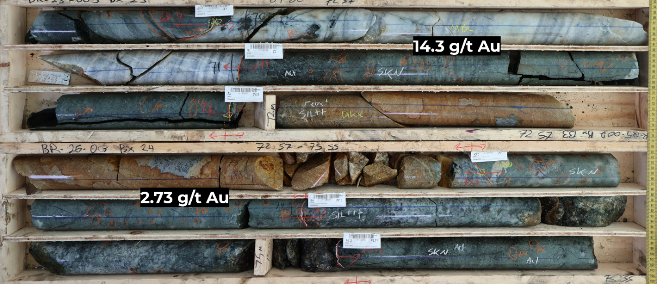

Figure 2 – Hole BR25-003 at 71m containing high-grade gold mineralization in strongly altered skarn surrounding a silica-sericite altered oxidised porphyritic dyke
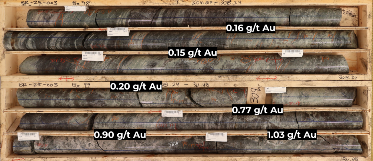

Figure 3 – Hole BR25-003 at 305m. Intensely altered gold-mineralized skarn horizon dominated by retrograde chlorite-actinolite-quartz alteration.
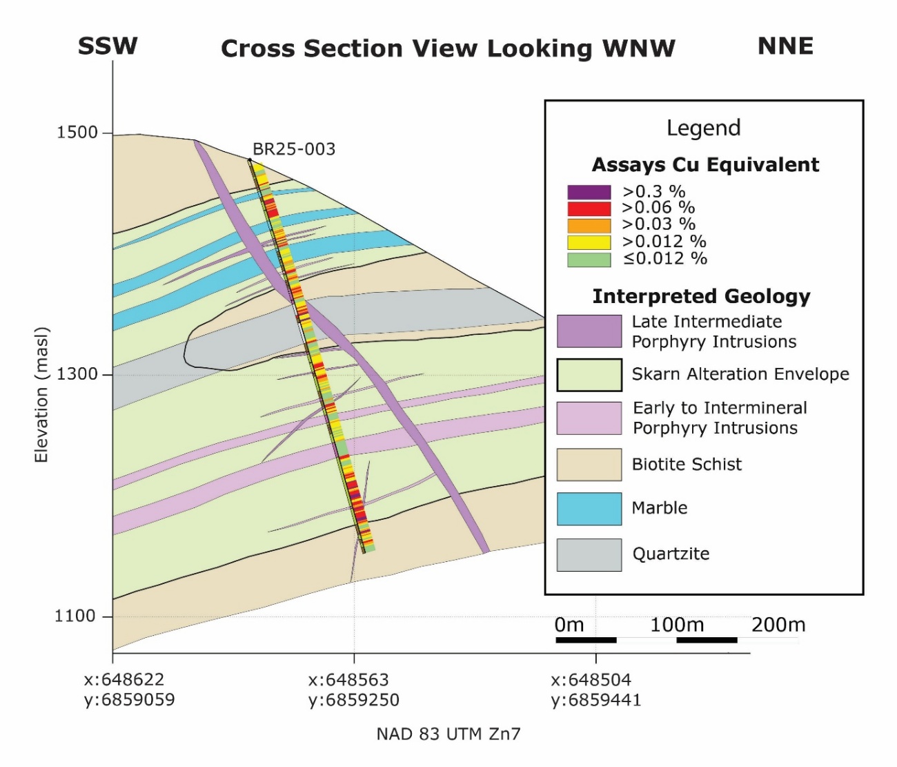

Figure 4 – Cross Section View of Hole BR25-003 with Copper Equivalent and Geologic Interpretation.
BR25-006
Hole BR25-006 tested additional horizons, downslope 200m to the north from Hole 1, within the marble-skarn sequence and encountered several narrow copper-gold-silver-bearing skarn intervals (Figure 6), including 0.6m of 1.22% Cu and 40.1 g/t Ag (Table 1, Figure 5). A deeper interval returned 6.0 metres of 0.19 g/t Au within the same stratigraphic package.
Significant intercepts from Hole BR25-006 include:
- 0.9 m of 0.52% Cu and 21.1 g/t Ag from 61.0m
- 0.6 m of 1.22% Cu and 40.1 g/t Ag from 84.5m
- 6.0 m of 0.19 g/t Au from 270.0m
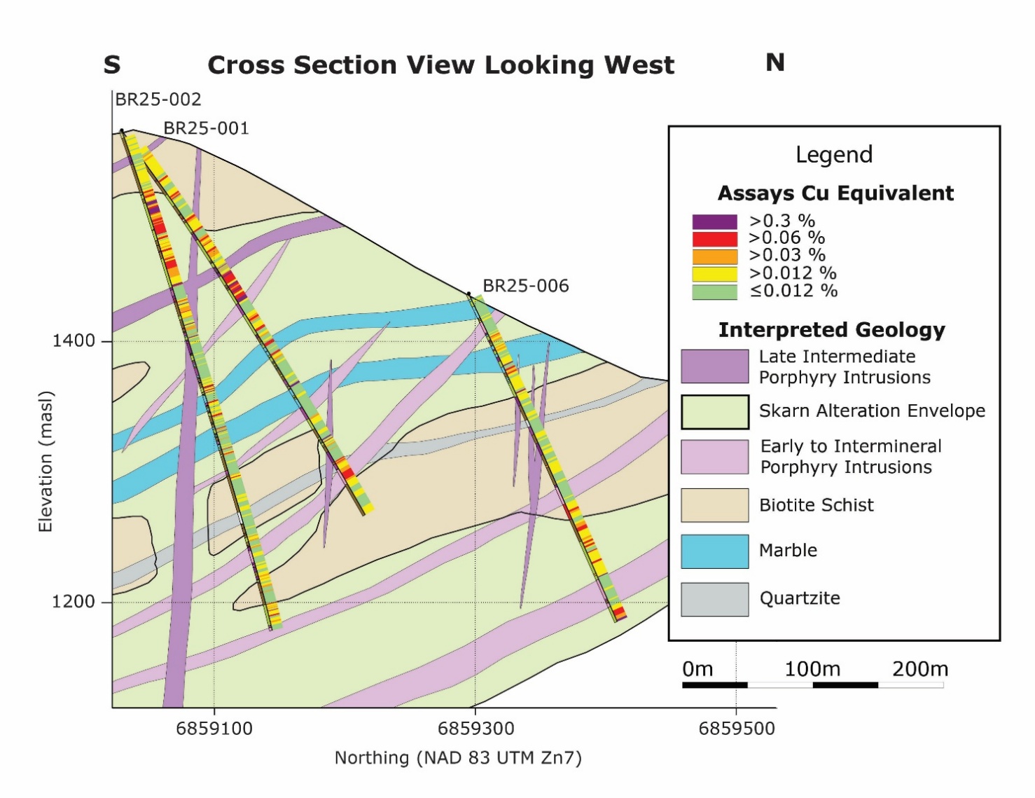

Figure 5 – Cross Section View of Hole BR25-001, BR25-002, and BR25-006 with Copper Equivalent and Geologic Interpretation.
| Table 1: Highlighted Drill Hole Assay Intervals |
| Hole_ID | From_m | To_m | Length_m | Au g/t | Ag g/t | Cu % | CuEq % |
| BR25-003 | 26.6 | 74.0 | 47.4 | 0.43 | 1.20 | 0.04 | 0.45 |
| incl | 35.9 | 45.5 | 9.6 | 0.32 | 2.25 | 0.06 | 0.38 |
| And incl | 45.0 | 45.5 | 0.5 | 3.70 | 27.90 | 0.60 | 4.38 |
| incl | 71.0 | 72.0 | 1.0 | 14.35 | 2.80 | 0.03 | 13.69 |
| 278.7 | 312.0 | 33.8 | 0.19 | 1.05 | 0.01 | 0.20 | |
| incl | 309.8 | 312.0 | 2.3 | 0.92 | 1.24 | 0.01 | 0.89 |
| BR25-006 | 61.0 | 61.9 | 0.90 | 0.09 | 21.10 | 0.52 | 0.8 |
| and | 84.5 | 85.1 | 0.6 | 0.37 | 40.10 | 1.22 | 1.95 |
| and | 213.0 | 214.5 | 1.5 | 0.25 | 0.60 | 0.01 | 0.25 |
| and | 270.0 | 276.0 | 6.0 | 0.19 | 0.65 | 0.01 | 0.19 |
Notes: True widths are not yet known but are estimated to be near true thickness based on current geological interpretation.*Copper equivalent (CuEq %) values have been calculated using the formula: CuEq % = Cu % + (Au g/t × 0.95) + (Ag g/t x 0.0095), based on metal prices of US $4.00/lb Cu, $3,000/oz Au, US $40/oz Ag. Recovery factors of 92% copper, 80% gold, and 60% silver were assumed based on a review of similar projects. No metallurgical test work has yet been completed at Birch.
Next Steps
A new property-scale geological map (Figure 6) and cross section (Figure 7) integrate updated mapping, geophysics, and multi-element geochemistry to outline a multi-pulse intrusive system responsible for skarn and potential epithermal and porphyry style mineralization at Birch. These datasets collectively highlight NW–SE trending intrusions as the principal controls on alteration and metal zonation, with proximal Au–Ag–Mo–Bi–Te–Cu enrichment grading outward into Pb–Zn–Sb halos. The resulting interpretation defines several circled targets across the property, including zones of skarn potential, epithermal potential, and porphyry potential, with the strongest clustering of indicators occurring south of the current skarn prospect.
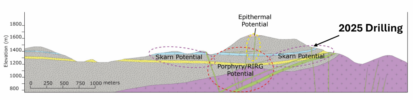

Figure 6 – Schematic cross-section across the Birch Project looking to the NW, showing key intrusive and metasedimentary units.
Building on the strong results from the 2025 program, the next phase of work at Birch will focus on step-out drilling down-dip to the south, where multiple datasets highlight the potential for an intrusive center at depth (Figure 8).
Additional infill drilling within the skarn zone is planned to improve continuity between the 2025 holes and refine the geometry of the stacked mineralized horizons. Yukon Metals will also undertake detailed geological mapping in the southern portion of the property and complete IP surveying, targeting chargeability and resistivity anomalies consistent with deeper sulfide or porphyry-style mineralization.
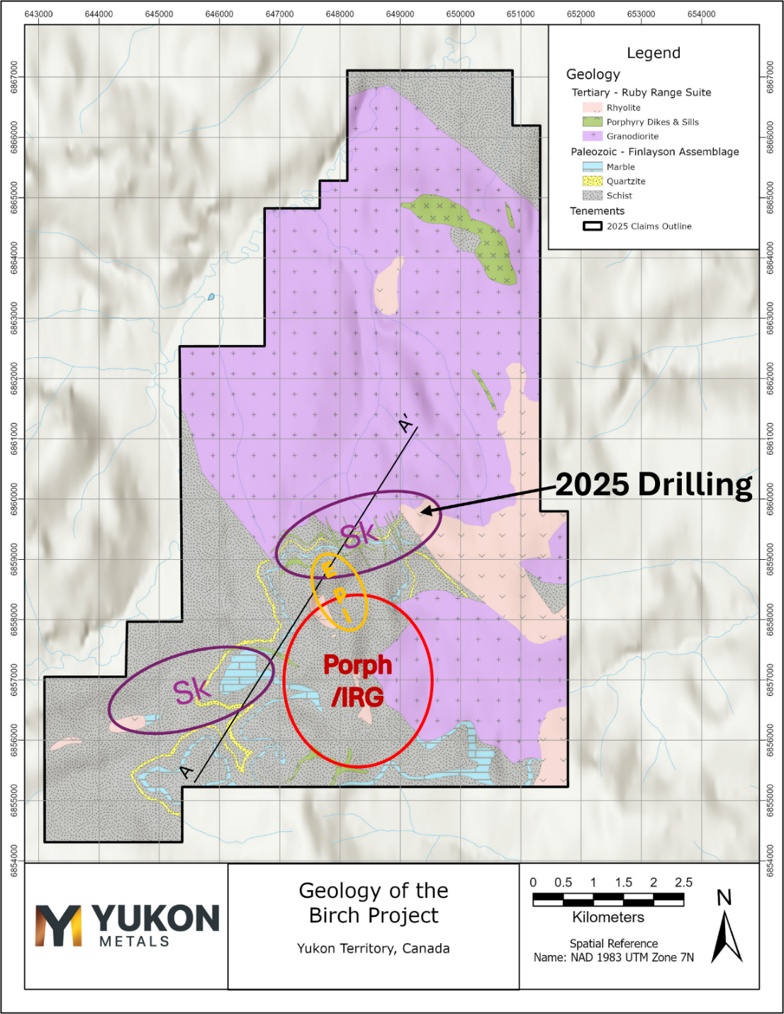

Figure 7 – Simplified geological map of the Birch Project showing key intrusive and metasedimentary units.
In parallel, the Company intends to begin systematic exploration of additional skarn and epithermal targets identified through updated geological, geochemical, and geophysical interpretations. These combined efforts will guide priority targets for the next drill campaign and continue to expand the mineralized footprint at Birch.
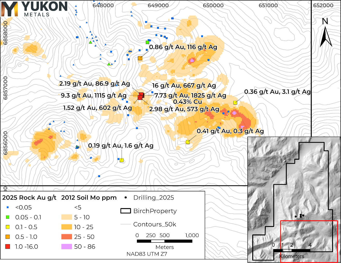

Figure 8 – Location of 2025 Rock Samples collected near the soil molybdenum anomaly on the southeast portion of the Birch property. 2024 Rock Samples are shown with triangle symbols.
| Table 2 – 2025 Birch Drill Hole Locations |
| Hole ID | Easting | Northing | Elevation | Total Depth (m) | Core Size |
| BR25-001 | 648314 | 6859029 | 1562 | 350 | HQ |
| BR25-002 | 648314 | 6859029 | 1562 | 401 | HQ |
| BR25-003 | 648587 | 6859167 | 1478 | 339 | HQ |
| BR25-004 | 647780 | 6859057 | 1550 | 285 | HQ |
| BR25-005* | 648317 | 6859295 | 1437 | 36 | HQ |
| BR25-006 | 648317 | 6859295 | 1437 | 273 | HQ |
*BR25-005 was ended early and redrilled due to poor ground conditions.
About the Birch Project
Yukon Metals owns 100% of the helicopter-accessed Birch project located 65 kilometres northeast of the community of Burwash Landing. The Birch project area is dominated by frost-heaved boulders in unglaciated terrain, with outcrop present on steeper ridges. The project lies predominantly within the Finlayson assemblage of the Yukon-Tanana Terrane, consisting of variably carbonaceous schist and quartzite, marble, garnet amphibolite and rare metaplutonic rocks.
The Yukon-Tanana Terrane structurally overlies the Ruby Range Batholith which is regionally mapped in the northeastern portion of the property occurring as Ruby Range quartz-feldspar porphyry and Rhyolite Creek porphyry and intermediate and felsic volcanic rock (Israel et. Al., 2011).
Yukon-based and Local First Nation Contractors Engaged
Drill pad construction at the Birch Property was completed by Minconsult in partnership with Vision Quest Drilling, a Kluane First Nation citizen-owned company. Helicopter support is being provided by Yukon-based Capital Helicopters. Drilling services were contracted to New Age Drilling in partnership with Vision Quest Drilling. Camp services were delivered by Käganì, a Kluane First Nation citizen-owned enterprise, in partnership with long-standing Yukon-based exploration contractor Archer Cathro.
QAQC
All diamond drill core from the 2025 program at the Birch Project was logged, photographed, and sawn in half using a diamond blade core saw. One half of the core was submitted for geochemical analysis, while the other half was retained in secure storage for reference. Sampling intervals were determined based on geological boundaries and typically ranged 0.3- 1.5 meters. Control samples comprised approximately 10% of all samples submitted, including certified reference standards, analytical blanks, field duplicates, and preparation duplicates.
QA/QC results were reviewed in real time, and all data have been verified as meeting acceptable thresholds for accuracy, precision, and contamination before inclusion in this release.
Drill core and rock samples were sent to ALS Minerals for analysis with sample preparation in Whitehorse, Yukon and analysis in North Vancouver, British Columbia. Samples were prepared by crush to 70% passing 2mm, 250g split pulverised better than 85% passing 75 microns (Prep-31A). Pulp samples were analysed for 34 elements by four acid digestion and ICP-AES (ME-ICP61). All samples were analyzed for gold by fire assay and AAS with a 50g nominal sample weight (Au-AA24). Samples over 10,000 g/t Cu were assayed by Ore grade Cu- Four Acid (Cu-OG62).
Rock samples taken while prospecting referenced in this release are selective in nature and collected to determine the presence or absence of mineralization and may not be representative of the mineralization hosted on the project.
Qualified Person
The technical content of this news release has been reviewed and approved by Helena Kuikka, P.Geo., VP Exploration for Yukon Metals and a Qualified Person (as defined by National Instrument 43-101).
About Yukon Metals Corp.
Yukon Metals is a well-financed exploration company with a 17-project portfolio covering more than 43,000 hectares. Built on over 30 years of Berdahl family prospecting, the same team behind Snowline Gold’s district-scale assets, YMC provides exposure to copper, gold, silver, and critical metals. While advancing high-priority drill targets at the Birch and AZ copper-gold systems and the Star River gold-silver project, the Company is also conducting generative exploration across its broader portfolio to develop the next pipeline of discovery opportunities. Guided by an experienced leadership team with technical, financial, and Yukon expertise, the Company is well positioned to unlock new mineral discoveries across the Yukon territory.
Yukon Metals is committed to fostering sustainable growth and prosperity within Yukon’s local communities, while also enhancing shareholder value. Rooted in a philosophy of inclusiveness and shared prosperity, the Company’s strategy offers both local community members and investors the opportunity to contribute to and benefit from its success.
The Yukon
The Yukon remains one of the world’s last underexplored mineral belts, offering exceptional discovery potential. The Territory is home to a highly skilled and conscientious local workforce, shaped by generations of exploration experience coupled with a deep respect for the land.
Recent major discoveries with local roots, such as Snowline Gold’s Rogue Project – Valley Discovery, highlight the Yukon’s potential to generate fresh district-scale mining opportunities.
ON BEHALF OF THE BOARD OF YUKON METALS CORP.
“Rory Quinn”
Rory Quinn, President & CEO
Email: roryquinn@yukonmetals.com
Phone: 604-366-4408
CAUTIONARY NOTE REGARDING FORWARD-LOOKING INFORMATION
This news release contains certain forward-looking information, including information about the metal association and geology of the prospect area at Birch pointing to the prospectivity for a gold-rich copper porphyry system, significant scale having been demonstrated by a soil anomaly over 1,400 metres long, the potential for economic grades of copper and gold based on grades taken from surface rock chips, the Yukon’s potential to generate fresh district-scale mining opportunities, and the Company’s future plans and intentions. Wherever possible, words such as “may”, “will”, “should”, “could”, “expect”, “plan”, “intend”, “anticipate”, “believe”, “estimate”, “predict” or “potential” or the negative or other variations of these words, or similar words or phrases, have been used to identify the forward-looking information. These statements reflect management’s current beliefs and are based on information currently available to management as at the date hereof.
Forward-looking information involves significant risks, uncertainties and assumptions. Many factors could cause actual results, performance or achievements to differ materially from those discussed or implied in the forward-looking information. Such factors include, among other things: risks and uncertainties relating to Chair Mountain and other properties not being prospective copper-rich, gold-rich or silver-rich geological systems; rock samples analysed not being representative of overall mineralization; the required assumptions of completed helicopter-supported mapping and sampling programs; not having significant scale and a lack of economic grade minerals; the Yukon not having the potential to generate fresh district-scale mining opportunities; and other risks and uncertainties. See the section entitled “Risk Factors” in the Company’s listing statement dated May 30, 2024, available under the Company’s profile on SEDAR+ at www.sedarplus.ca for additional risk factors. These factors should be considered carefully, and readers should not place undue reliance on the forward-looking information.
Although the forward-looking information contained in this news release is based upon what management believes to be reasonable assumptions, the Company cannot assure readers that actual results will be consistent with the forward-looking information. The forward-looking information is made as of the date of this news release, and the Company assumes no obligation to update or revise the information to reflect new events or circumstances, except as required by law.
REFERENCES
Israel, S., Murphy, D., Bennett, V., Mortensen, J. and Crowley, J., 2011. New insights into the geology and mineral potential of the Coast Belt in southwestern Yukon. In: Yukon Exploration and Geology 2010, K.E. MacFarlane, L.H. Weston and C. Relf (eds.), Yukon Geological Survey, p. 101-123.
Photos accompanying this announcement are available at:
https://www.globenewswire.com/NewsRoom/AttachmentNg/c47c7c47-6f67-481f-a117-685446c1129e
https://www.globenewswire.com/NewsRoom/AttachmentNg/6d45951c-1f62-4960-bf2d-241da90c7bd1
https://www.globenewswire.com/NewsRoom/AttachmentNg/953e22ac-c0a1-42ae-9f07-e9c1b1398223
https://www.globenewswire.com/NewsRoom/AttachmentNg/0fa230e5-b4ee-4573-b660-31bad2f44b5e
https://www.globenewswire.com/NewsRoom/AttachmentNg/3a97936f-32f6-4b02-9dd1-bea4e9c31154
https://www.globenewswire.com/NewsRoom/AttachmentNg/6d47a275-11a4-4e79-add2-3f5caa81e7f0
https://www.globenewswire.com/NewsRoom/AttachmentNg/b06f2b7f-6de3-4fb2-9879-466671f9d3bb
https://www.globenewswire.com/NewsRoom/AttachmentNg/3a715f5e-95ba-4653-91e1-5ca297431984
![]()

